Public comments have made a difference in the draft 2017 Louisiana Coastal Master Plan, one official told south Louisiana reporters Monday. And public comments still can.
The comment period lasts through March 26. You can see the draft report and make comments online at coastal.la.gov.
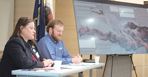
Brady Couvillion, research geographer for the U.S. Geological Survey, and Nedra Davis, Nedra Davis, executive director of the Chenier Plain Coastal Restoration & Protection Authority, talked Monday to the Acadiana Press Club at the National Wetland and Aquatic Research Center. Listening to them, you get the idea that the minds behind the plan would welcome help from any source.
Public comments resulted in 22 changes in the draft plan, Davis told the reporters.
“The plan is going to be based on the best available science,” Davis said. “But we want public input.”
The challenges are daunting.
That’s true even in the Atchafalaya coastal region, for which Berwick is the eastern boundary, where new coastal land actually is being created by sediment flowing into the Gulf from the Atchafalaya River itself and the Wax Lake Outlet. And that’s certainly true in the Terrebonne coastal zone, for which Morgan City is the western boundary, which is among the regions losing land at the greatest rate.
New estimates based on federal research into climate change, which have been incorporated into the 2017 draft, say that what had been considered the worst case for sea level rise, about 2.7 feet over the next few decades, is now considered the best case.
That’s bad news for a state that has lost 183,000 square miles of coastal land in the last 80 years, equivalent to the area of Delaware. That’s about like losing Manhattan Island every year or a football field every hour.
The culprits, Couvillion said, are that sea level rise; subsidence of the land itself; storms that rip away coast land; the levees that deprive the coast of the sediment that would renew and expand natural wetlands; and infrastructure features, such as canals that allow salt water to infiltrate coastal marshes.
And that, in turn, is bad news for a commercial fishery second only to Alaska’s; four of the nation’s top ports; the 20 percent of the of nation’s oil and gas supply that moves through the Louisiana coast; threatened and endangered species that make coastal Louisiana their home; and humans threatened or endangered by storm surges that can be reduced by a healthy coastal zone.
The coastland wetlands at issue are “incredibly valuable,” Couvillion said. “But we’re losing them at a staggering rate.”
And the coastal restoration plan, designed to guide the spending of $50 billion over the next 35 years, isn’t a complete solution.
Davis said drafting the original plan involved whittling $270 billion in needed projects to $50 billion. Even with the money Louisiana will receive because of the Deepwater Horizon spill settlement, the plan remains underfunded.
Even if it is fully funded, Couvillion said, the plan won’t be an all-encompassing fix. The goal is to sustain or build 800 square miles of coastal land over the life of the plan.
But for the next 50 years, “all the models suggest that we will have fewer wetlands than we do now,” Couvillion said.
Priorities differ from area to area, she said. In the Chenier Plain region, the emphasis is on shoreline protection, Davis said. Statewide, the priority is creating new marshland.
The marshland priority helped push one project that St Mary officials sought. The 2012 plan included money for a $100 million structure to prevent Bayou Chene back-flooding. Last January, a sunken barge was used to block back-flooding, and officials were hoping for a permanent solution.
The Bayou Chene work was dropped from the 2017 draft plan. State Sen. Bret Allain, R-Franklin and a member of the Senate Natural Resources Committee, has threatened to hold up approval of the master plan if the Bayou Chene work isn’t in it.