It’s not an egret, and it’s not a cropduster — it’s a sounding balloon.
T. Gregory Guzik with Louisiana State University’s Department of Physics and Astronomy said, “The reason we are in Church Point is because we have about five or six launch sites in the area — here, in Elton, Eunice and Jennings are our primary ones, sort of in a circle.
“Depending on how those high altitude winds go, they’ll blow the balloon east or west or north or south. We choose our launch site so that we can come down more in a clear area rather than getting into the forest.”
Guzik continued, “These areas where we have the rice fields and crawfish ponds are more preferable than the trees in north Louisiana or the marsh in south Louisiana or in the Atchafalaya. We usually launch in the area west of Interstate 49, north of Interstate 10 and east of Lake Charles. It’s (the land is) pretty much flat and accessible with reasonable roads, that sort of thing.”
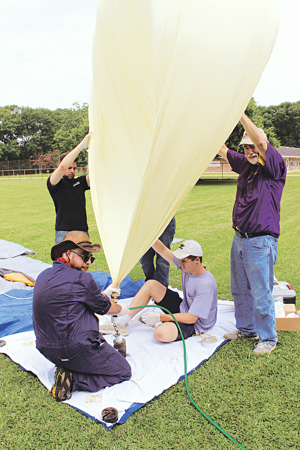
Guzik along with fellow LSU Professor Dan A. Browne, graduate students Emma Western and Aaron Ryan, Anthony Ficklin, research staff member, and undergraduate students Blaine Irle and Jacob Miller were at the Church Point baseball complex June 26 to launch a sounding balloon.
The purpose of the flight was to test equipment used in the college’s Louisiana Aerospace Catalyst Experiences for Students (LaACES) program, which provides students a two semester project culminating with the flight of a scientific balloon experiment. The equipment items tested during the flight were an electronic kit for students, a replacement tracking and balloon system control or megabeacon and a 360-degree camera. The LaACES program began in 2003, and this is the 64th balloon launched through the program.
The balloon, made out of latex rubber and weighing about 2,000 (28.6 ounces) grams, was 8 feet in diameter once inflated. Once the balloon reached its destination altitude of 90,000 feet, Guzik said the pressure decrease would likely cause the balloon size to increase to 40 feet in diameter. Payload items attached to the balloon were: a parachute, which would transport the payload items back to the ground; a terminate package to release the payload from the balloon when it reached its destination altitude; a primary balloon tracker with a GPS unit and radio transmitter; a test payload; a secondary tracker beacon; a GPS controlled 360 degree camera; the mega-sat or electronic kit that will be used to train students in electronics programming; a test replacement for the primary balloon tracker; a third positioning backup which uses iridium satellites; and a few antennas. The balloon’s payload had an estimated weight of about 12 pounds.
“Once we record and get the camera back down, it will know its orientation via GPS, so when we process that image, we can actually fix the geographic coordinates/geographic orientation so we can actually see the horizon and the rest of the view fixed while the balloon looks like it is spinning around and around,” Guzik said. “It will automatically, through computer software, sort of de-spin and stabilize the image. This will be the first time we will be flying that one.”
Guzik said the third positioning backup communicates to satellites in orbit what the balloon’s position is and that information is transmitted down to the iridium ground station.
“Then that information is actually emailed to a central server which is based in Montana, no less,” he said. “We can get on the Internet and see all that position information. One of the reasons why I always fly one of those is because that is what we call ‘over the horizon,’ so no matter where it is, on the ground or in a tree, as long as it isn’t underneath the water in a crawfish pond or something like that and shorted out, it will transmit to those satellites.
“These guys with the big antennas at the bottom, those are what I call ‘line of sight.’ We can only see those when we can get to the radio signals. If we drop below 2,000 feet, 1,500 feet, depending on how far away we are, we’ll lose those signals. Otherwise, we will see it throughout the flight. We’ll see those signals throughout the flight while we’re standing here as well as the iridium. We can get close with these other things, but with the iridium, we know exactly where it’s come down.”
After a successful launch, Guzik checks the balloon on his laptop.
“It’s doing well,” he said. “It will take the balloon about 90 minutes to reach its altitude and about half an hour to 45 minutes to fall back down.”
A visit to LaACES flights page later showed that the balloon traveled east to just about the Leonville area, then back west just north of Church Point and on to the Richard area. The balloon then traveled back east before turning sharply back north and landing just south of U.S. 190 near Mallet.